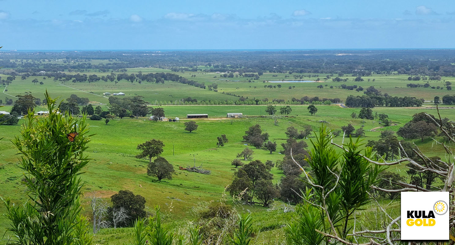
⛏️ Kula Gold Limited is pleased to report results from ongoing exploration activities at the Donnybrook Gold Mine (“DBGM”) Prospect within their 100% owned Brunswick Project in the southwest region of Western Australia (Figure 1).
HIGHLIGHTS (Download the full PDF)
- Rock samples up to 7.95g/t Gold at the Donnybrook Gold Mine Prospect, Brunswick Project, Southwest Region.
- Soil samples up to 176ppb Gold, in ~250m wide, NNW- trending zone striking over 650m and open.
- 2 gold micro nuggets panned from nearby new White Sands Prospect.

Figure 1. Location map of Kula’s Brunswick Project including the Donnybrook Gold Mine (DBGM) Prospect, and the new White Sands Prospect.
Soil sampling has defined a zone up to approximately 250m wide with a current strike of 650m NNW (open in both directions) with anomalous gold in soils up to 176ppb, and rock samples to 3.47g/t gold.
Soil sampling also revealed an approximate 300m x 200m area of copper anomalism immediately northeast of Mt. Cara, with values up to 219ppm copper, as presented in Figure 5. This area remains open to the north.
Kula geologists continue reconnaissance at the DBGM Prospect to field-truth historical data and interpretations compiled from open file reports, obtain rock samples to verify historically reported grades, as well as start to build a geological understanding of the gold mineralisation.
Further work includes additional soil sampling, geological mapping, and geological review of all data to define and rank drill targets.
Gold micro nuggets have been panned from creeks originating within volcanic tuff at the new White Sands Prospect, which is located approximately 6km northeast of the DBGM Prospect (Figure 1).
TECHNICAL DETAILS
Rock Sampling Results
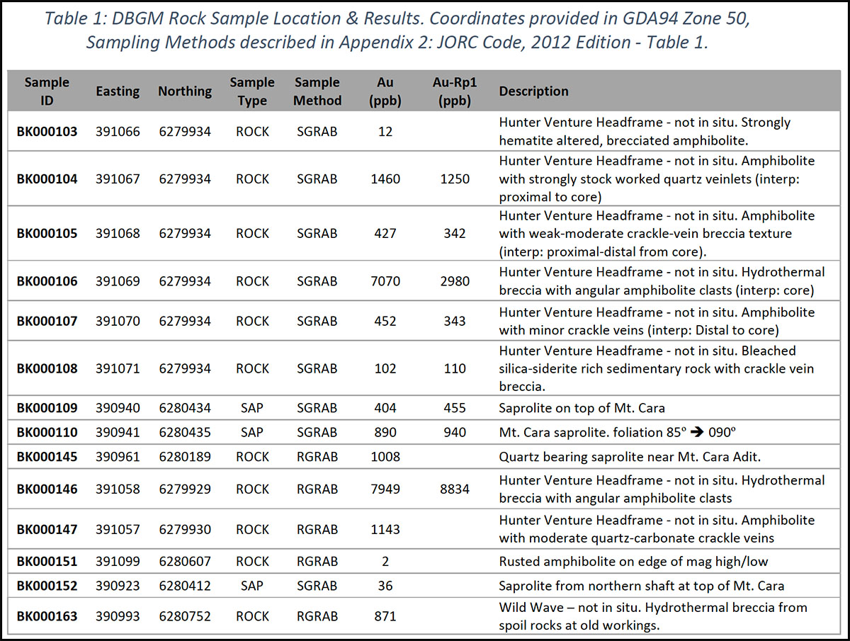
The location and results of rock sampling by Kula is shown in Figure 2 with a summary of gold results for all rock samples taken by Kula at the DBGM Prospect attached in Appendix A: Table 1. Photographs of selected rock samples are presented in Figure 3.
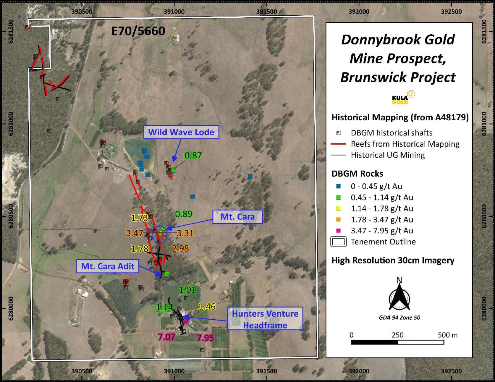
Figure 2: Location and gold results for rock samples taken at DBGM. Also showing location of historical shafts, reefs from historical mapping, and outlines of historical underground development (after Chalmers, 1996).
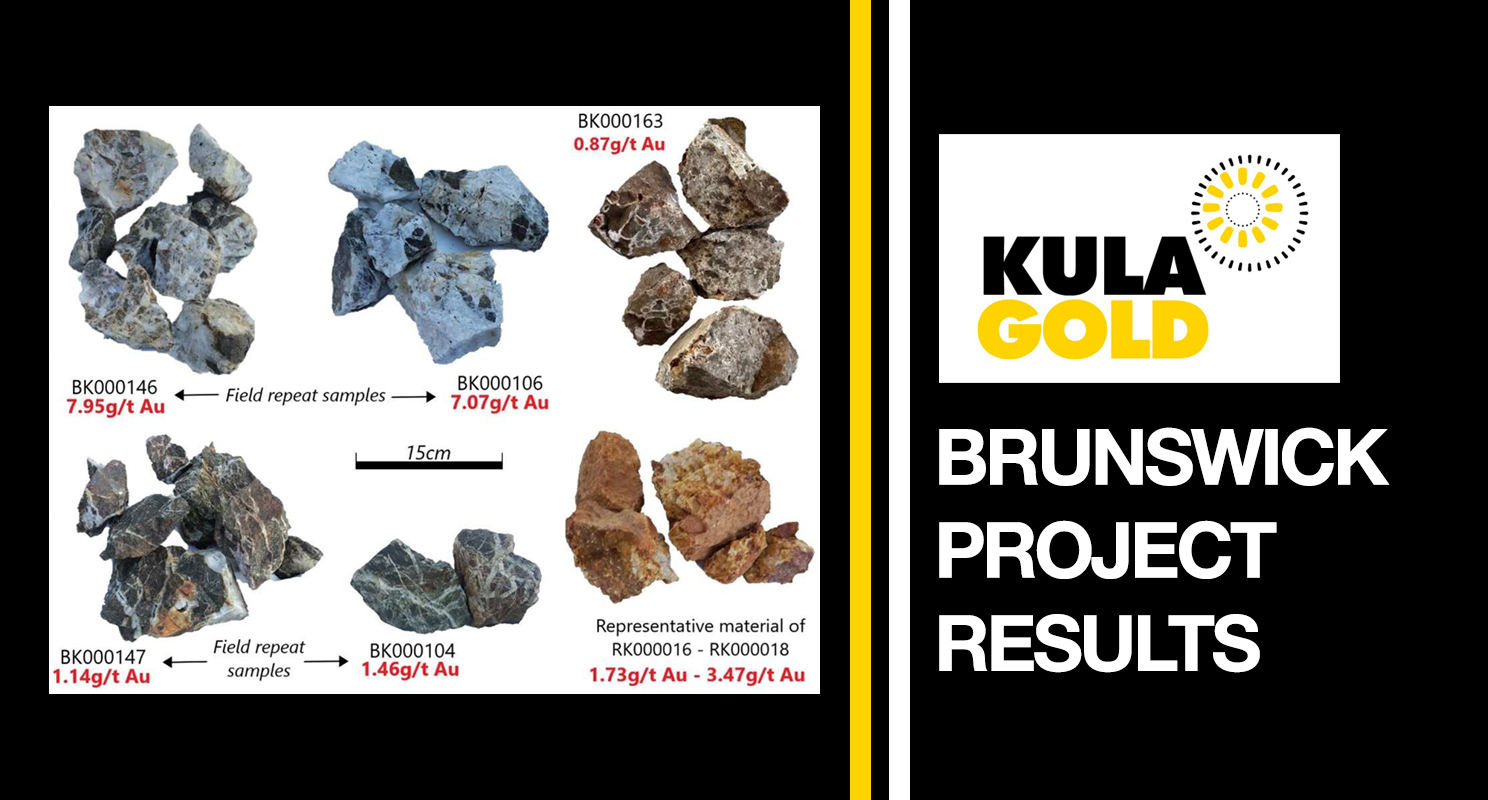
RK000016 – RK000018 were obtained across a 50cm zone of exposed saprolite at the top of Mt. Cara (Figure 2) and returned results ranging 1.73g/t– 3.47g/t gold.
Sample BK000145 of quartz-bearing saprolite located close to the Mt. Cara Adit, returned 1.01g/t gold.
Field repeats of the previously reported rock samples from spoil material sitting around the Hunters Venture Headframe (ASX release 30th September 2021) have confirmed initial high grade results – hydrothermal breccia (Figure 3), interpreted to be the core of the epithermal system, returned 7.95g/t gold (with a lab repeat value of 8.83g/t gold – BK000146), and amphibolite with quartz-carbonate crackle vein-‘breccia’ (interpreted to be from mineralisation sited proximal to the core) in BK000147, returned 1.14 g/t gold.
Wild Wave (Figure 2) was historically interpreted as a sub-parallel lode to the main mineralisation, supported by a 0.87g/t gold result returned from sample BK000163 of hydrothermal breccia (Figure 3), obtained from spoil rocks at the Wild Wave historical workings/test pits.

Figure 3: Rock samples from DBGM Prospect, with their respective grades. Hydrothermal breccia (BK000106, BK000146 & BK000163), amphibolite with quartz-carbonate crackle veining (BK000104 & BK000147), and representative material of saprolite material sampled from the old shaft at the top of Mt. Cara (RK000016 – RK000018).
Soil Sampling Results
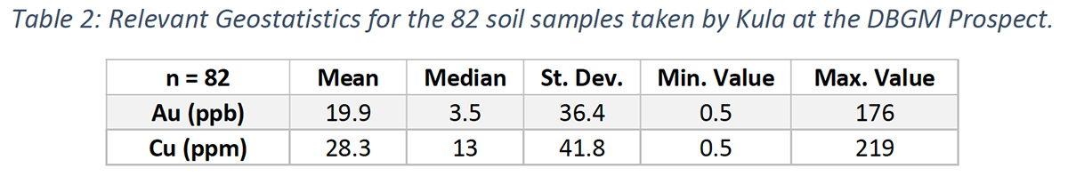
82 soil samples were taken across Mt. Cara to test the mineralised reefs recorded in historical mapping. Lines were extended east and west of the mapped reefs to ascertain the width extent of gold-in-soil anomalism.
Results show an approximately 250m wide zone extending 650m along the NNW strike direction, of +20ppb gold anomalism with a peak value of 176ppb gold, as presented in Figure 5. Relevant geostatistics are presented in Appendix A: Table 2. Gold-in-soil anomalism remains open in both strike directions.
The overall NNW-trend of the gold-in-soil anomalism, coupled with the spatial correlation of the high values of 140ppb gold and 161ppb gold with the historically mapped reefs supports the information presented in historical reports. Furthermore, high values of 140ppb gold and 176ppb gold in areas of no historical mapping (indicated in Figure 4) suggests potential for the presence of undiscovered reefs.

Figure 4: Kula’s soil and rock sampling location map, showing gold results (with soils > 2ppb Au & rocks > 100ppb Au labelled). GNS (geologically not sampled) indicates where an attempt at a sample was made, however the transported material was too deep to obtain a sample from the B Horizon so no sample was taken. For visual reference, the generalised area of copper-in-soil anomalism is outlined in pink on this map (with full data presented in Figure 5)
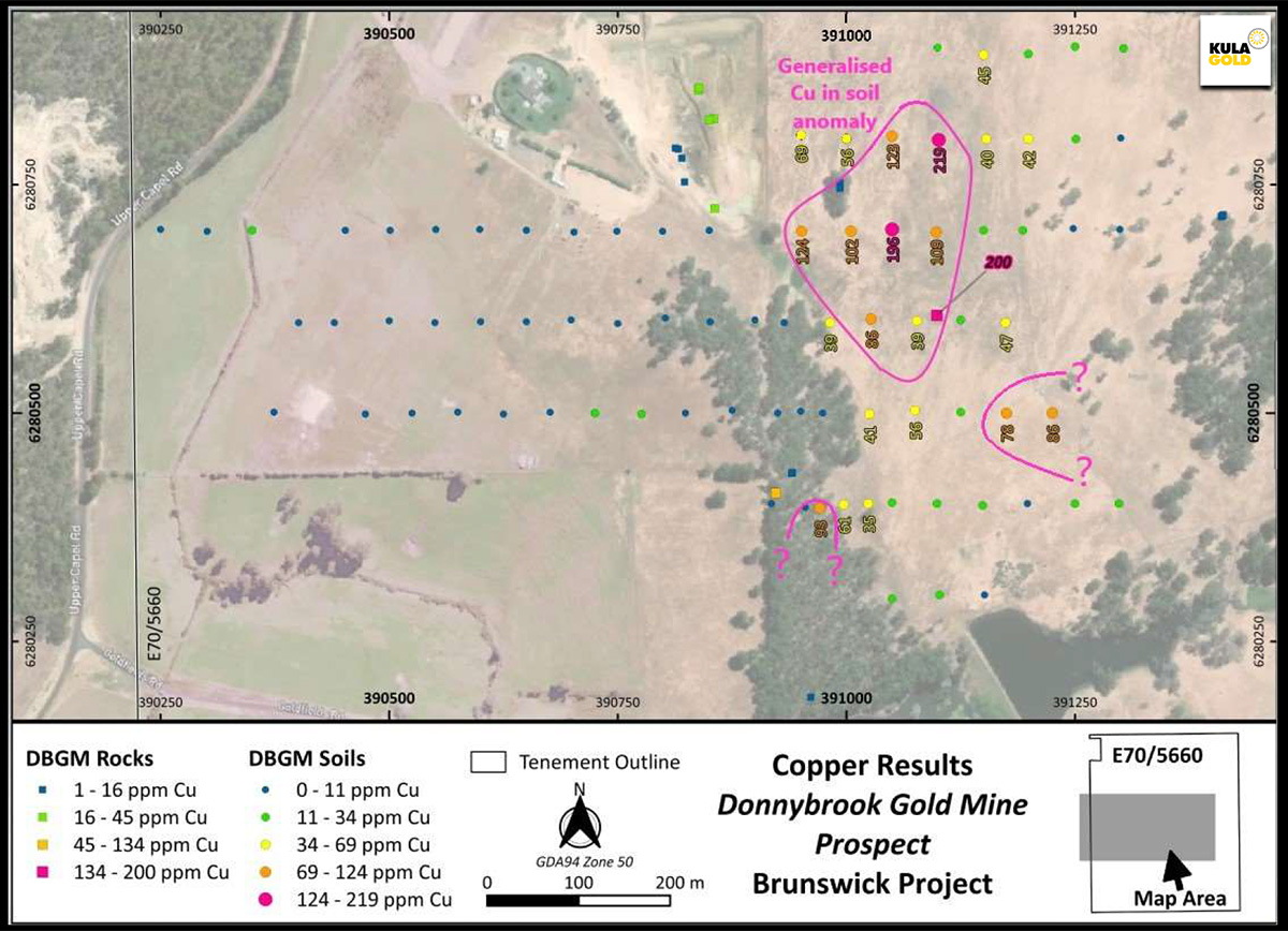
Figure 5: Kula’s soil and rock sampling location map, showing copper results (with soils > 34 ppm Cu & rocks > 134 ppm Cu labelled) and generalised area of copper anomalism indicated in pink. The strike of anomalism is unknown at this stage—further work is required.
Soil sampling revealed an approximate 300m x 200m area of copper anomalism northeast of Mt. Cara, proximal to Wild Wave, with values up to 219ppm copper, as presented in Figure 5. This area remains open to the north. Further work, including follow up sampling of the two other areas of elevated copper-in-soil values indicated in Figure 5, is required to understand the relevance, orientation, and extent of the copperin-soil anomalism at the DBGM Prospect.
The next stages of work at the DBGM Prospect includes:
- Additional soil sampling lines to test gold-in-soil anomalism extents immediately north and south of Mt. Cara, plus soil sampling of accessible ground surrounding the Hunters Venture Headframe to test and link gold-in-soil anomalism from Mt. Cara to the Hunters Venture area.
- Extension of current soils lines where required to follow up and further define the elevated copperin-soil values.
- Detailed geological mapping to assist in determination of any structural and/or lithological controls on gold mineralisation.
- Comprehensive review of all geological data, to define and rank targets for drill testing.
WHITE SANDS PROSPECT
Reconnaissance work has identified quartz rich, volcanic tuff (see inset photo in Figure 6) at the White Sands Prospect, which provides evidence of explosive volcanism within the region. The topographic cross section indicates that White Sands sits within a slight depression, surrounded by slight topographic highs where volcanic tuff has been observed. A subtle ellipsoidal ring (indicated in Figure 6), which appears coincident with the subtle topographic highs, can be seen in the magnetics surrounding the White Sands Prospect—it is possible that this feature represents a remnant tuff ring (refer Figure 6 inset image).
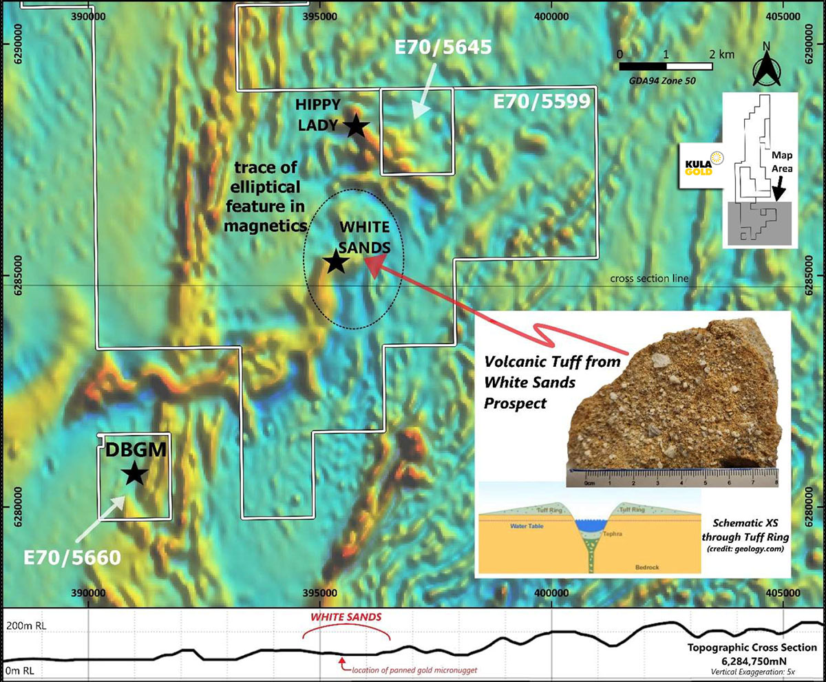
Figure 6: Location of White Sands, DBGM & Hippy Lady Prospects overlain on regional magnetics (TMI RTP over TMI-RTP-1VD shown). Magnetics sourced from Collie SI5006 Survey. Inset image showing Volcanic Tuff obtained from White Sands Prospect and a schematic cross section through an idealised tuff ring. Topographic cross section showing location where gold micro nuggets were panned.
Further work, including mapping the tuff extents and 3D inversion modelling of the publicly available magnetic data may provide evidence to substantiate this theory. Given that White Sands is situated only 6km northeast of DBGM, Kula geologists are investigating if the volcanism at White Sands may have been the geological driver for the Donnybrook epithermal system.
In areas previously quarried for silica sands, the surface has been mined back to expose saprolitic volcanic tuff, with channels and valleys cut through over time by creeks accommodating surface drainage (Figure 7A).
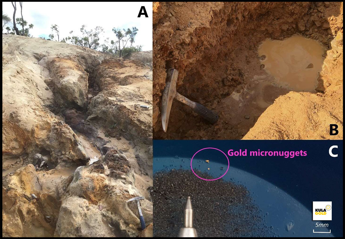
Figure 7: Photographs from the White Sands Prospect. Showing A: creek channels cut into the exposed saprolitic volcanic tuff (geopick for scale) which are typical at the White Sands Prospect. B: Gold panning hole dug in the small delta formed by the creek channels at the small dam (geopick for scale), and C: gold micro nuggets panned at White Sands Prospect.
Two gold micro nuggets (Figure 7C) were panned by a Kula geologist and local prospector from hole dug (Figure 7B) within the mouth of a small dam (Panning conducted in a small, seasonal dam located approx. 395625mE, 6284515mN) where the creeks formed a delta. The creeks that flow into the dam originate within White Sands Prospect which means the source of this gold is likely within the prospect area. Auger and/or aircore drilling is being planned to further test the potential for gold anomalism at White Sands.
Kula geologists will continue to work on building the geological observations from White Sands into the local and regional geological interpretation, to help determine if there is a geological link between DBGM and the White Sands volcanism and will use this new information to assist in targeting other areas of potential gold mineralisation for further reconnaissance work.
References: Chalmers, DI (1996). Open File Report A48179: Donnybrook Project, Annual Report for period 16/12/1994 to 15/12/1995, E70/1172. Genesis Resources. NL.
APPENDIX A.

Download the full PDF to view all JORC Tables in APPENDIX B.
Location view of Kula Gold’s Brunswick Project in Western Australia
News Release
Date: 4 July 2022 | ASX Code: KGD
Competent Person Statement: The information in this report that relates to geology and exploration is based on information compiled by Mrs. Melanie Hickman, a Competent Person who is a member of the Australian Institute of Mining and Metallurgy and the Australian Institute of Geoscientists. Mrs. Hickman is a Geology and Exploration Consultant who has been engaged by Kula Gold Limited. Mrs. Hickman has sufficient experience, which is relevant to the style of mineralisation, geology and type of deposit under consideration and to the activity being undertaken to qualify as a competent person under the 2012 edition of the Australasian Code for Reporting Exploration Results, Mineral Resources and Ore Reserves (the 2012 JORC Code). Mrs. Hickman consents to the inclusion in the report of the matters based on her information in the form and context in which it appears.
About the Company
Kula Gold Limited (ASX: KGD) is a West Australian gold exploration company focussed on large land positions and structural geological settings capable of hosting ~1m oz deposits. The company has various gold, copper, nickel, PGE, lithium, halloysite and kaolin projects across the Southern Cross region including Marvel Loch, Rankin Dome and Westonia, as well as at Brunswick and Kurnalpi-Lake Rebecca. The company has a history of large gold resource discoveries with its foundation Woodlark Island Project in PNG.
Contact the Company Secretary on Tel: +61(08) 6144 0592 or via cosec@kulagold.com.au


